
When we were kids in class when they asked us for a map of Spain to study geography, locate rivers and locate mountain ranges, we went to the bookstore. There they gave us a sheet and with it in the folder we went so excited to school. They were different times.
Today fathers, mothers, teachers, and students have the opportunity to download maps of Spain online . You don't have to go to the bookstore your whole life. And there are all kinds of them: a map of Spain with communities, physical maps, with rivers, maps of Spain with provinces or even road maps (although for that, most will opt for Google Maps nowadays).
In this special about maps of Spain to download we wanted to compile a whole series of maps with good quality. They will be useful to you whether you want to practice your knowledge about autonomous communities, as if you want to teach the rivers to students or get them to learn the capitals of our provinces at once.
In total, more than 150 images with free maps of Spain to download to your computer.

Political map of Spain
Political Spain map
Political maps of Spain are probably the most used by students and teachers . They may include information of a different nature, either individually or in combination. That is, names of provinces, capitals, counties and autonomous communities.
They are very practical to learn the names of each of these places and regions . Then, combined with silent maps, they can help us contrast knowledge. If you are not studying, you also have interesting options. Especially if you want to consult some of these maps to see exactly where a specific city is located or print it to have it always present in the office or office.

Maps of the autonomous communities of Spain.
If geography was never your strong suit, this will help you to always know where to direct your gaze. It doesn't matter if they talk to you about Cuenca, Malaga or Zamora. Here are ten political maps to locate the autonomous communities (1, 2, 3, 4, 5, 6, 7, 8, 9 and 10), but also the provinces and Spanish capitals (1, 2, 3, 4, 5 , 6, 7, 8, 9 and 10). These maps usually include both at the same time. Here we have shared with you a bit of both.
Finally, we want to remind you that each of the Spanish provinces is also divided into regions. Learning the regions can be a feat, only suitable for fans of geography, but who knows. In the following section, specific to communities, we will help you find the best complete maps of each of the regions of Spain.

Map of Spain by communities
Our country, Spain, is divided into different autonomous communities . Each with its own idiosyncrasies. It may be that on some occasions, especially when dedicating yourself to learning different concepts, qualities and characteristics of the region, you need to access a specific map of each community.
That is why we wanted to provide you with different maps for each of the Spanish autonomous communities . In this way, you will not need to get lost in a thousand searches through Google. These are the best maps that you can download and print for free of the different autonomous communities. You have them, then, arranged alphabetically to make it easier for you to locate them.

Map with the provinces of Andalusia
- Andalucía . One of the areas with the greatest architectural, cultural and gastronomic wealth and variety. Of this community you have maps with the different provinces, by counties, biodiversity, more regions and provinces, a basic map of provinces, roads, more provinces, roads and bus stations, physical and orographic, mute, mute river or mute of provinces.
- Aragon . If you are looking for maps of Aragon, here is a map of regions in color, orographic, roads, hunting grounds, Romanesque routes, provinces. You will find everything you need and if you want more, you can carry out specific searches to find important tourist enclaves, charming nature trails or routes to do in the snow.
- Asturias . We have also found many maps of Asturias: one of the most charming places in our country. We have Romanesque routes, a tourist map, of protected natural areas, towns and regions and even sports activities.
- Balearic Islands . Who cannot fall in love with our Balearic Islands? Whether you study them or visit them, on Google you will find physical maps, a silent map, islands and towns, a political map and even a hydrographic map.
- Canary Islands . If you want to download maps of the Canary Islands, you will also find many on the Internet. This will be great for you to know all the islands that make up the archipelago. You also have a silent map, ideal for students learning the different islands. If you are going to visit them, this will be very good for you to know the different tourist attractions.
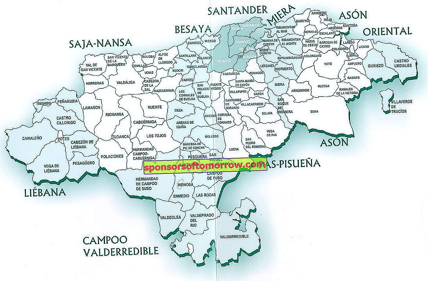
Map with the different regions of Cantabria

- Cantabria . You can't take Miguel Ángel Revilla with you everywhere, so it never hurts to get a good map of Cantabria. If you plan to visit the region, here you will find a political map with the different regions. It will be good for you to get an idea of the territory you are going to visit. Here you have a guide with roads and another with that of the most important towns. And if you want to take a look at the Romanesque routes, here is another map to download of very good quality. Later we will help you find maps of curiosities, natural places and cultural routes to enjoy the community.
- Castilla and La Mancha . And now let's go to Castilla y La Mancha, the endearing lands of Don Quixote. Here is a super practical and easy to understand graph, by province. You will see that there are also the roads and different towns, to guide you well. If you are about to learn the provinces of this community, here is a silent map to train you.
- Castile and Leon . Do you know the regions of Castilla y León well? Do you have all the cities well located? If not, maybe you should take a look at this political map. Here you can see all the provinces in a very clear way. We have also found a map of cities, towns and counties, a blank map to guess the provinces and another with the most important towns.
- Catalonia . And now let's continue with Catalonia. Whether you plan to visit the Catalan autonomy, or if you are going to learn the most important provinces and localities, we have maps for all needs. Here we provide you with a basic map with the four provinces, another with all the regions and a silent one, in case you are interested in learning the provinces. We have also found a physical map, which will help you to know the orography of the region.
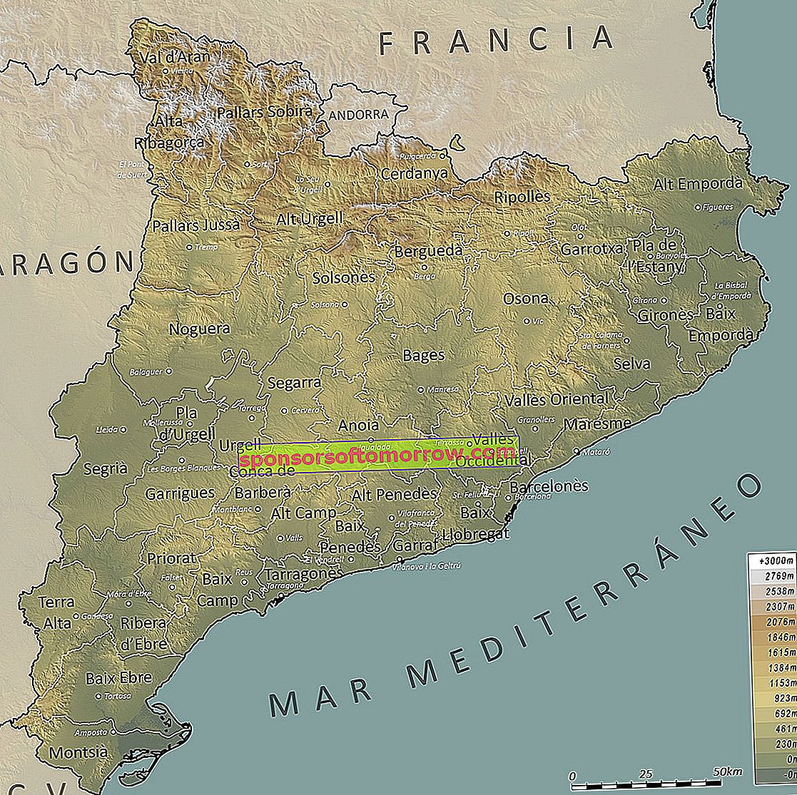
Catalunya physical map

- Ceuta . If you want to get to know Ceuta up close, you can also download specific maps of this community. Here we have a political map, with the most important points. We have found a map of the port of Ceuta, a street map and even a satellite map.
- Valencian Community . We continue with the Valencian Community. You have at your fingertips some interesting physical maps (1, 2, 3, 4) that will help you to know what the physical anatomy of this Spanish region is. We have also found a game to learn the different regions. On the Internet we will find county maps and city and road maps. If you are interested, you can also access a dialect map. But if you are looking for a truly complete map of the Valencian Community, here you have the most complete of all.
- Extremadura . To know Extremadura like the back of your hand, all you have to do is download these maps. This is very complete, because it includes information on the main cities and roads of the autonomous community. Here you have a silent map and the physical map, to see the different mountain ranges, rivers and different orographic points of interest.
- Galicia . Let's go up to the North of Spain to see maps of Galicia. Here we have one with the four provinces, seen in a very graphic and simplified way. We also include a silent map, on which we can later deposit our knowledge of the different cities and provinces. This map can also be useful to draw pictures inside. It will have a basically educational use. If you need it for tourist use, here is a map with the main locations with hotels. Finally, we have found a political map with all the regions, great for students.
- La Rioja . The land of good wine, among many other things. This is La Rioja. So let's start with a very good quality tourist map, which you can print and carry under your arm to any route. But don't think that this is the only one. We have located an environmental map, another well-made tourist map, a physical road map with designations of origin, a political and road map, and a blank map.
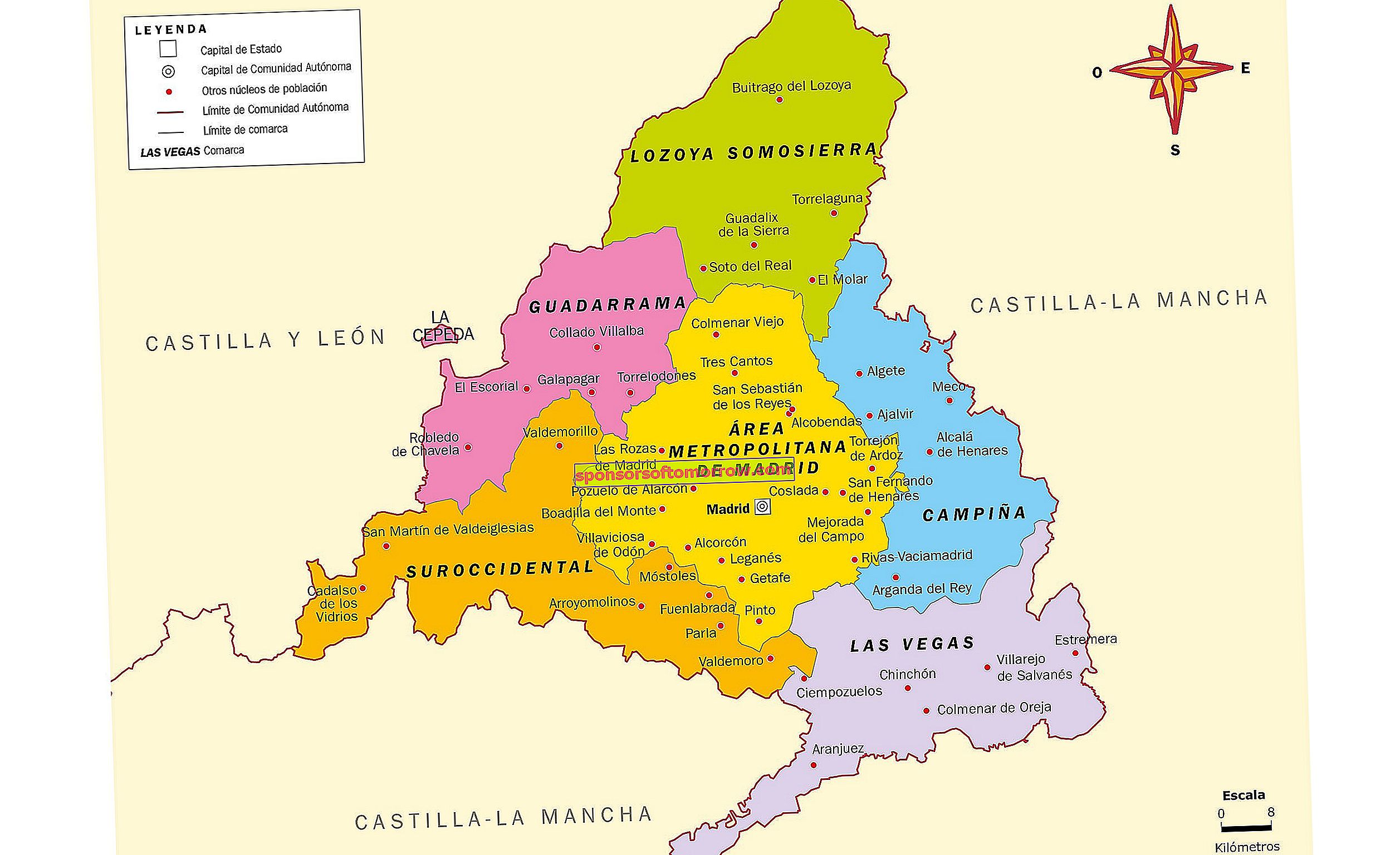
Political map with the cities and towns of Madrid

- Madrid . We are in Madrid, the community of the capital of Spain. Physical and political center of the bull skin. If you want to get maps of Madrid, you will find endless options on the Internet. Here we have a political map, a physical map, a similar map, and a mute map. Here you will find different physical spaces, but also the rivers that somehow pass through the Community of Madrid. If you need to know the different municipalities, you can access this other map, complete and of very good quality.
- Melilla . Let's now take a look at the maps of Melilla. We have a map of the city and other images that will be useful if you plan to visit Melilla.
- Murcia . The Murcia region is another of the great Spanish communities. You have the possibility to download different maps of cities, roads, regions and another with different cities in Murcia online. If you need it, you will also have the opportunity to download a blank map and another to locate different municipalities.
- Navarra . The foral community of Navarra is another of the most emblematic places in Spain. We have found maps of all kinds, so through Google you can download maps in many different formats. Here you have a political map with different cities and roads, another physical map to see the characteristics of the terrain, the forests and Navarre forest areas, a map with some of the most important towns, the different merindades, the forest map, all the towns and finally, a silent map in which to locate the cities and towns that we want.
- Basque Country . And we end up with the last community, in alphabetical order, from which we can download maps through the Internet: the Basque Country. Here we have a political map with the main regions, a blank map, one of roads and another with the most important cities.

Physical map of Spain
Physical maps are those that include information about the terrain . Thus, we can find general physical maps, with data on almost the entire geography, but also specific maps of rivers and mountain ranges. Some come with topographical and political indications, others are silent, so that students can write down the names, learn them, and study them. It would suffice, in that case, to confront it with a map that is not mute.
On the Internet we have countless proposals to find a physical map of Spain to download. Here you will find a good number of physical maps that will come in handy, in general, to know the physical characteristics of our country: mountains, ranges, mountain ranges, valleys, rivers, reservoirs, etc. Here you have a very complete physical map and other options to download that will also be great for you (1, 2, 3, 4, 5).
If you need silent physical maps, don't worry, because you can also access a lot of them. You will find them more classic, but you will also see that there are more current maps, with designs in pleasant colors or even in black and white. In this way, it will always be easy for you to write on it and that what you write is understood correctly. This comes in handy when writing between small spaces (especially when we need to name mountain ranges or rivers).

Map of Spain with the main rivers
Map of Spain with rivers
We also have river maps. These are the ones that show the route of the rivers and their tributaries on the surface of the map . A network of aquatic networks that we often find difficult to identify. At school this is one of the basic lessons in physical geography, so maps can be a great help for study.
If you are also curious about nature and want to know where some of the main Spanish rivers are born, as well as knowing what their tributaries are, the river or hydrographic maps of Spain will also suit you very well .
Here you have one of the maps, with all the tributaries, maps to play to learn the rivers and others with the main ones. We have found very graphical, easy to understand options and other maps, which you can use as an exercise to identify the different rivers and seas. If you need an even whiter, mute map, here is another one that will come in handy to write inside and do it in a clear and clean way .

You also have silent river maps to identify the rivers.
Map of Spain mute
What is a silent map? Silent maps are those that geographically or politically represent a territory. Usually, they offer us information about provinces or communities (you will find them in this and other modalities), but in a silent way. That is, without lettering.
Due to their characteristics, they are usually used in the field of education. And is that to being empty, enable students to recognize in them the different geographical and political areas . Teachers often use them to help their students identify different points and, logically, locate them on the map.
If you are looking for a blank map of Spain, you will find many to download on the Internet. You must bear in mind, of course, that there are different types. Some serve to identify the provinces, other for communities or even rivers .
If you are looking for a typical blank map of Spain, here is the basic one. In this you can easily and clearly identify the Spanish autonomous communities . Here you have it in colors, to locate the provincial capitals. This is a completely silent map, in which you can make drawings or write inside. The latter can come in handy, for example, to make illustrations about the different Spanish traditions, typical dishes, languages and dialects used. The options are endless, so you can start downloading (1, 2, 3, 4, 5, 6, 7, 8, 9, 10).
In this large map you can also identify the provinces . Although of this style you will find infinite options: this with the islands, another with the autonomous communities of colors, the provinces, the provincial capitals with legends, the climates, the orography and the mountain systems.
Learning the rivers is another of the great tasks that primary and secondary school students face . So most likely teachers and professors will ask students for blank maps to identify rivers. Of these you also have many on the Internet. You can find them simpler, in white colors and in other shades, a little more sophisticated (1, 2, 3, 4, 5, 6, 7, 8, 9, 10).

Tourist maps of Spain
Spain is a rich and diverse country , where you will find spaces of all kinds. We have a wonderful Mediterranean, with big cities like Barcelona or Valencia. To the north we have large communities, such as Galicia, Asturias, the Basque Country or Cantabria: colder landscapes, perhaps more rainy, but absolutely imposing. In the center we have architecture, culture and gastronomy in Madrid, La Mancha, León… and to the South, what can we say about the South?
Hence, tourist maps make so much sense in Spain . We can enjoy countless cultures, customs and different cuisines within the same territory. Through the Internet we can find great maps for sightseeing and locate the different traditions on the map.
This map will help us to recognize some of the most important monuments in the country and here we will find, in the form of drawings, the most relevant monuments and heritage of each territory. Then there is also the possibility of downloading tourist maps of each of the regions and cities of Spain . For example, you have tourist maps of La Rioja, Madrid, Barcelona, Valencia or Andalusia.
If you want to find a tourist map (you can also search directly) by city, autonomous community or route through Google. Imagine you want to visit Cabárceno park. Type "Cabárceno map" in the search engine and click on the Images tab . Here you will find countless interesting maps and in a very good resolution.
Another practical example: the map of the Quixote Route through Castilla y La Mancha. Type "Quijote route map" to get image results. You will see that there are from historical maps to proposals specially made for people who today want to go to La Mancha to walk in the footsteps of the Knight Walker.
Games to print and learn the map of Spain
Learning the maps of Spain may seem, at first, a somewhat arduous and cumbersome task. Nothing could be further from the truth. We can also make it fun . If you are a teacher, father or mother, we have for you a good assortment of games that you can download and print.
These are specific games to learn the maps of Spain, such as this one of autonomous communities. It is a puzzle in which you will have to cut out the different communities and direct your students or children to place them on top of the silent map . You can invent different games and have a fun time, while learning political geography.
Here you have another assortment of autonomous communities to print and cut. If you put them all together in the correct way, you will get the map of Spain . You can do it with a guide in front. To do this, download a political map of the ones that we have proposed above.
You also have the option to print this colorful blank map of Spain. You can play with one or several, to guess the autonomous communities, provinces and even capitals. Before, logically, we will have to have studied with a physical map and then try to guess where Palencia, Albacete or Lleida is located . Could you specify it on top of a map?
If you want to play in a more interactive way (and practice before you start playing on paper), you can try these interactive Didactalia maps. From here you can go studying and testing your skills with Spanish geography. Of course, in that case you will not be able to print the maps: you will do everything in the browser .